
Welcome.
Drones make aerial imaging realistic, easy and repeatable as a primary method of understanding archaeological sites and landscapes, both in structure and in context.
This project gathers drone images to examine how they are to be handled singly and together, and to assess also how they relate to parallel possibilities, for example mapping, and images from Google Earth.
The images are freely available. Full data files (for printing) for academic use are available from the secretary.
The law concerning the majority of drones was revised in July 2018 to require that they should not be flown within 1 km of an airport nor above 120 m, anywhere, in the United Kingdom.
Previously there were no restrictions.
A hidden connection is stronger than an obvious one. Heraclitus
Notes
Look for a display prompt at the bottom of your browser screen If an image does not open,.
If you experience problems with pdf images, try an alternative browser.
If a pdf image appears blank, right-click the downloaded screen and ‘save as’ the file to a chosen location. Open in your pdf display programme (commonly Adobe Reader).
Images on this website above 120 m were acquired before the change in the law affecting drones.
Website last updated
28.01.19
Revisiions.
www.aerialsurveyarchaeology.uk
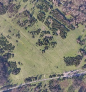
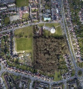
Sutton Park, on the southern edge of Staffordshire, has a long archaeological record dating back to at least Mesolithic times. A series of agricultural events is recorded in the first set of images, in a small area close to Holly Hurst and to the north of Powell’s Pool. The sequence ends with the pathways of recent visitors. The second sequence is of the north side of Powell’s Pool where a mill/blade factory was located in the eighteenth and nineteenth centuries. Dumping of material dredged from the pool can also be seen.
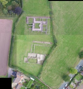
The Roman town of Letocetum, modern Wall village, near Lichfield, Staffordshire, had its origins in military activity during the reign of the emperor Claudius (AD 41-54). By the time of Hadrian in the second century, Letocetum had gained public buildings, of which the mansio and public baths are known by their excavated remains; a fourth century stone burgus enclosure is also recorded as standing until recent centuries. The name Lichfield is derived from Letocetum.
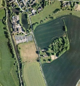
Acton Trussell is a village 4 miles south-east of Stafford - known as Actone in Domesday. In 1985 Roman remains were discovered south-east of St. James’s Church, and excavation was undertaken. This showed that a wing of a Roman villa had been found. A later watching brief when work was undertaken in the church, confirmed that the building extended to at least the tower, 43 m away. Continuing excavation outside the churchyard since has shown the remains to be 2nd to 4th century in date. Neolithic, Bronze Age and Iron Age activity has also been discovered.

Allow pdf images full page and and then zoom (ctrl +) !
content
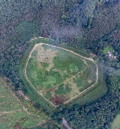
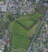
Wroxeter, Latin Viroconium Cornoviorum-Viriconium of the Cornovians, lies beside the River Severn 5 miles south-east of Shrewsbury. It was the fourth largest tribal capital in Roman Britain, and at its height had a population of about 15,000. It began life as the legionary fort of Legio XIV Gemina, in about AD 58, replaced some years later by Legio XX Valeria Victrix.. As a centre of population it survived to the end of the Roman period and beyond - considerable evidence for later activity has been shown.
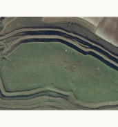
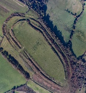

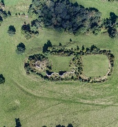
Arbor Low, Derbyshire
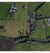
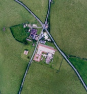
Wychnor, Domesday Wicenore, is a Staffordshire deserted mediaeval village to the north of Alrewas close to the Roman Ryknield Strreet (modern A38). The remains are of a deserted medieval village, a moated site, moated enclosure and fishponds. It is well preserved. The hall on the moated site was demolished by 1535, which suggests a decline for Wychnor around this time.
There has been some new building since, at around the beginning of the last century.
content